 Kento-Kun
In this memo, I’ll walk you through how Japan’s Urbanization Control Areas work.
 Kento-Kun
It may seem a bit technical, but once you understand this concept, you’ll see how it influences where buildings can be placed across Japan.
An Urbanization Control Area is a zone designated within a city planning region, where urbanization is expected to be restrained rather than uncontrolled. Although the term uses “control,” its real role is more about regulation and limitation.
Urbanization Control Areas are zones where urbanization should be restrained.
— Source: Article 7, Paragraph 3 of the City Planning Act
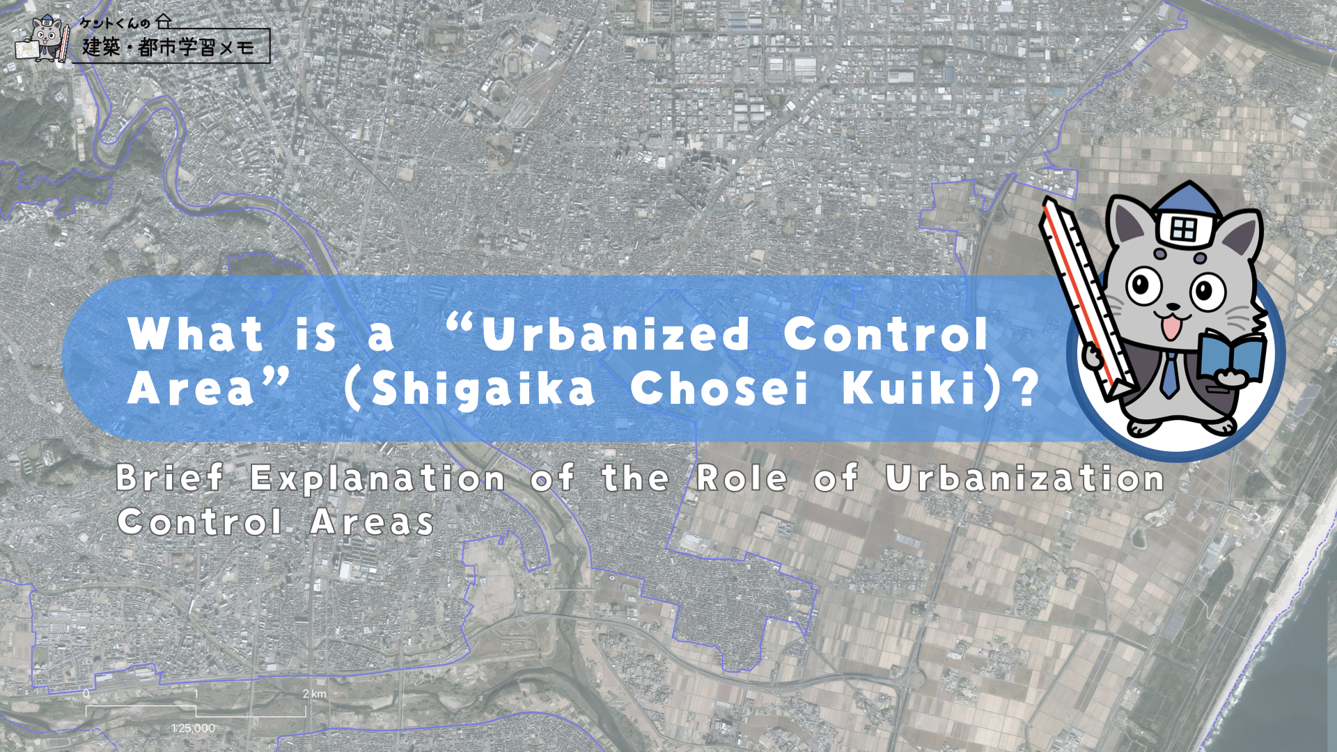
Kento-KunBelow is a map example from Sendai City showing how blue lines differentiate Urbanized Areas from Urbanization Control Areas. In this map, farm fields are included in the control zones.
This system was introduced in 1968, when the City Planning Act was enacted. Before that, during the 1950s and 1960s, Japan experienced rapid population growth and rampant urban sprawl — unplanned subdivisions, narrow roads, limited infrastructure, and unstable land were common in suburban fringes.
This kind of sprawling growth occurred not only in Tokyo, Osaka, and Nagoya, but also in regional cities. As cities expanded outward indiscriminately, effective planning became very difficult. To address this, the government introduced Urbanization Control Areas to help local authorities restrain city expansion. At the same time, Urbanized Areas were designated to concentrate development in certain spots. Together, these designations are referred to as area classifications(kuiki kubun).
Kento-KunOne of the central roles of Urbanization Control Areas is to enforce a land-use standard: you cannot build new structures without permission. This permission is called development permission, regulated under Article 43 of the City Planning Act.
There are also exceptions. For example, those working in agriculture, forestry, or fisheries may build industry-related structures without full permission or via a streamlined process. But they must consult local authorities and submit proof of their agricultural activities.
Without obtaining the permission of the prefectural governors, any person must not, in any area in urbanization control areas other than development areas for which the development permission has been granted, newly build any buildings other than those prescribed in Article 29, paragraph (1), item (ii) or (iii) or newly construct any category 1 special structures, nor must remodel them to buildings other than those prescribed in item (ii) or (iii) of that paragraph by reconstructing any buildings or changing their uses; provided, however, that this does not apply to the following kinds of new building, reconstruction or change of use of buildings or new construction of category 1 special structures:
— Source: Article 43, Paragraph 1 of the City Planning Act
 Kentto-Kun
However, how this permission is applied is left to each local government—usually the prefectural government or, in some special cases, major city governments. Because urban management is closely connected to politics and economics, some localities have recently moved to abolish or reclassify their control zones.
As of March 2024, Urbanization Control Areas cover approximately:
- About 9.95% of Japan’s national land is designated as Urbanization Control Area.
- Roughly 37% of all City Planning Areas fall under control zones.
- Despite this, over 90% of the population lives within City Planning Areas, which make up only around 30% of the nation’s land.
hese City Planning Areas include not only mega-cities like Tokyo, Osaka, and Nagoya, but also regional urban zones with populations of roughly 100,000+ forming interconnected planning regions. In contrast, mountainous or less populous municipalities often do not include control zones because development pressure is low.
| Year (as of March) | Total Population (1,000s) | City Planning Area (ha) | Population within City Planning Area (1,000s) | Urbanization Control Area (ha) |
|---|---|---|---|---|
| 1990 | 122,745 | 9,353,822 | 111,630 | 3,706,940 |
| 2000 | 126,071 | 9,854,140 | 116,418 | 3,773,562 |
| 2010 | 127,058 | 10,069,048 | 119,517 | 3,736,888 |
| 2020 | 127,138 | 10,246,045 | 119,939 | 3,767,323 |
| 2024 | 124,885 | 10,286,191 | 118,302 | 3,759,717 |
 Kento-Kun
You can check the designated areas on the MLIT’s official website:
▶︎ https://www.mlit.go.jp/toshi/tosiko/genkyou.html
After reading this memo, I hope you better understand the role of Urbanization Control Areas!
Let’s protect our beautiful mountains and farmland together!
Over the past 35 years, the area designated as Urbanization Control Area has repeatedly increased and decreased.
One reason is the 2000 revision of the City Planning Act, which excluded major urban areas from zoning boundaries, giving them more flexibility.
In addition, the population concentration in large cities and the abolition or relaxation of Urbanization Control Area designations have also influenced this trend.
Kento-KunSummary
・As a rule, you cannot build in an Urbanization Control Area without permission.
・Permission is handled by local governments, with some flexibility in enforcement.
・The system helps protect farmland, forests, and natural landscapes around cities.
・Exceptions exist for those in agriculture, forestry, or fisheries.
Because implementation varies by locality, this law’s real impact differs across Japan.
・I hope this version feels natural and easy to follow.
Kento-Kun hopes more people will understand how these systems quietly shape our everyday lives.


コメント